Our Changing Earth: 7 Class NCERT CBSE SST Geography
Question: What are lithospheric plates?
Answer:
- The lithosphere is broken into numerous pieces
- These big pieces are called lithospheric plates
- The earth’s crust consists of several large and small, rigid, irregularly shaped plates/pieces.
- The movement of these plates causes changes on the surface of the earth.
Question: Why do the lithospheric plates move slowly?
Answer: The lithospheric plates move slowly because of the slow movement of molten magma inside the earth in a circular manner.
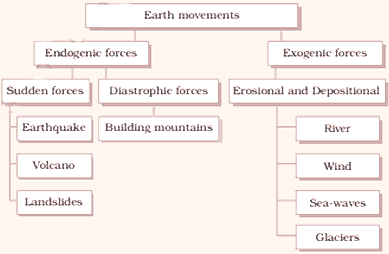
Question: What are the two types of the earth’s forces?
Answer:
- The earth’s movements are divided on the basis of the forces which cause them
- The forces which act in the interior of the earth are called endogenic forces
- The forces that work on the surface of the earth are called exogenic forces
- Endogenic forces sometimes produce sudden movements
- At other times they produce slow movements
- Sudden movements are earthquakes and volcanoes
- They cause mass destruction over the surface of the earth
Question: Define a volcano.
Answer: A volcano is a vent or a hole in the earth’s crust through which molten material erupts suddenly.
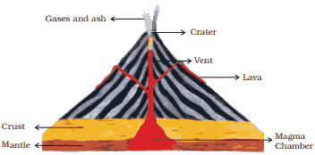
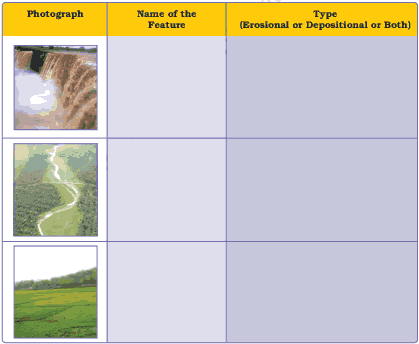
A Volcano
Question: What are earthquakes? Define focus and epicentre.
Answer:
Earthquake:
- When the lithosphere plates move, the surface of the earth vibrates
- The vibrations travel all around the earth
- These vibrations are called earthquake
Focus: The place or point in the crust where the movement starts is called Focus
Epicentre: The place or the surface above the focus is called epicentre
- Vibrations travel outwards from the epicentre as waves
- Greatest damage occurs closest to the epicentre
- The strength of the earthquake decreases, going away from the center
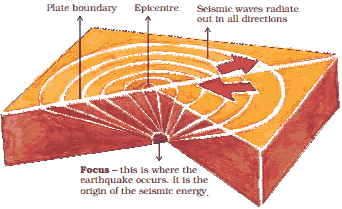
Origin of an Earthquake
Question: What are three types of earthquake waves?
Answer: There are three types of earthquake waves:
- P waves or longitudinal
- S waves or transverse waves
- L waves or surface waves
Question: How can we minimize the impact of an earthquake?
Answer:
- Earthquakes cannot be predicted.
- Their impact can certainly be minimized if we are prepared before hand.
Question: Give an account of some common earthquake prediction methods adopted locally by people.
Answer: Some of the common earthquake prediction methods adopted locally by people are:
- Wild animal behavior
- Agitated fish in the ponds
- Snakes coming out to the surface from their holes
- Animals trying to untie themselves and run away
- Birds leaving their nests and beginning to chatter loudly
- Aborigines beginning to run to higher grounds
Question: What is seismograph? How is the magnitude of earthquake measured?
Answer:
- An earthquake is measured with a machine.
- It is called a seismograph.
The magnitude of the earthquake is measured on Richter scale.
- An earthquake of 2.0 or less is felt only a little.
- An earthquake over 5.0 causes damage from things falling.
- A 6.0 or higher magnitude is considered very strong and 7.0 is classified as a major earthquake.
Question: Explain Earthquake preparedness.
Answer: Earthquake Preparedness:
When an earthquake strikes we should do the following:
- We should be in a safe spot like: under a kitchen counter, table or desk
- We should stand against an inside comer or wall
- We should stay away from fire places, areas around chimneys, windows that shatter including mirrors and picture frames
- We should be prepared by arousing awareness amongst our friends and family members
- We should face any disaster confidently
Notes: Case Study Bhuj Earthquake:
- An earthquake measuring 6.9 on richter scale hits Bhuj in Gujarat
- Schools worst affected
- Communication water power supply affected
- Hundreds of fire started
- Emergency declared and CM appeals for help
Major Land Forms
Question: What are the two processes which continuously wear away the landscape? Explain them.
Answer: The Processes: The landscape is continuously worn away by two processes.
They are:
- Weathering and erosion.
- Weathering is the breaking up of rocks on the earth’s surface.
- Erosion is the wearing away of the landscape by different agents like water, wind and ice.
- The eroded material is carried away or transported by water, wind etc.
- They deposit material eventually.
- This process of erosion and deposition creates different landforms on the surface of the earth.
Work of a River
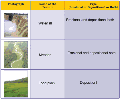
Question: What is a waterfall? Explain with example.
Answer: When the rivers tumble at steep angle over the hard rocks of a deep steep valley it forms a waterfall.
For example: Victoria waterfalls or Niagara waterfall.
Question: Describe the work of a river.
Answer:
Work of a River:
- Running water in the river erodes the landscape.
- When the river tumbles at steep angle over very hard rocks or down a steep valley side, it forms a waterfall.
- When the river enters the plain it twists, turns and forms large bends. These bends are known as meanders.
Due to continuous erosion and deposition along the sides of the meander, the ends of the meander loop come closer and closer.
- In due course of time the meander loop cuts-off from the river and forms a cut-off lake.
- It is called an ox-bow lake.
- At times the river overflows its banks.
- This leads to the flooding of the neighbouring areas.
- The flood water deposits layers of fine soil and other material.
- They’are called sediments, along its banks.
- This leads to the formation of a flat fertile land called a flood plain.
- The raised banks are called levees.
As the river approaches the sea, the speed of the running water decreases.
- The river begins to break up into a number of streams. They are called distributaries.
- Now the river becomes so slow that it begins to deposit its load.
- Each distributary forms its own mouth.
- The collection of sediments from all the mouths forms a delta, the triangular shaped land mass.
Work of Sea Waves
Question: Write a note on the work of sea-waves.
Answer: Work of Sea Waves
- Erosion and deposition of the sea waves form coastal land forms
- Sea waves continuously strike at the rocks
- Cracks develop
- In course of time they become larger and wider
- Hollow like caves are formed on the rocks
- They are called sea caves
- As caves become bigger and bigger only the roofs of the caves remain. This leads to formation of Sea arches
- Continuous erosion breaks the roofs and only walls are left
- These wall-like features are called stacks
- The steep rocky coast rising almost vertically above sea water is called sea cliff
- The sea waves deposit sediments along the shores
- This leads to formation of sea beaches
Question: Describe the work of ice.
Answer: Work of Ice:
- Glaciers are “rivers” of ice
- They too erode the landscape by bulldozing soil and stones to expose the solid rock below
- Glaciers carve out deep hollows
- As the ice melts they get filled up with water and become beautiful lakes in the mountains
- The material carried by the glacier like big and small rocks, sand, silt gets deposited
- These deport from glacial moraines
Question: Give an account of the work of wind.
Answer: Work of Wind: An active agent of erosion and deposition in the deserts is wind.
In deserts there are numerous rocks with a shape of a mushroom.
- They are commonly called mushroom rocks
- Winds erode the lower section of the rock more than the upper part
- Such rocks have narrower base and wider top
When the wind blows, it lifts and transports sand from one place to another.
- When it stops blowing, the sand falls and gets deposited in low hill like structures
- These are called sand dunes
When the grains of sand are very fine and light, the wind carries it over very long distances.
- When such a sand is deposited in large areas, they are called loess. Large deposits of loess are found in China.
Question: Fill in the blanks with appropriate words:
- Magma inside the earth moves in a ………………………. motion.
- A ………………………… is a vent in the earth’s crust through which molten material comes out.
- The place in the crust where the earthquake starts is called ……………………..
- The processes of …………………………….. and ………………………. create different landform on the surface of earth.
- Deposition of layers of fine soil along the bank of rivers forms …………………………….
- Sand deposits over larger areas are called………………………….
Answer:
- circular
- volcano
- epicentre
- erosion, deposition
- flood plains
- loess
Question: Write whether the given statements are true or false:
- Sudden movements like earthquake do not cause mass destruction
- Deposition is breaking up of rocks on the earth’s surface
- Wearing away of the land by different agents like water, wind and ice is called erosion
- Sea caves become bigger and only the roof remains forming the sea arches
- Moraine is a depositional feature of glaciers
- River is an agent of erosion and deposition in the desert
Answer:
- False
- False
- True
- True
- True
- False
Question: Answer the following questions briefly:
- Why do the plated move?
- What are exogenic and endogenic force?
- What is erosion?
- How are flood plains formed?
- What are sand dunes?
- How are beaches formed?
- What are ox-bow lakes?
Answer:
- The plates move because of the movement of the molten magma inside the earth.
- Exogenic forces: The forces that work on the surface of the earth are called as exogenic forces.
Endogenic forces: The forces that act in the interior of the earth are called as endogenic forces. - Erosion is the wearing away of the landscape by different agents like water, wind and ice.
- During floods, layers of fine soil and other material called sediments are deposited on the river bank. This leads to the formation of a flat fertile flood plains.
- Sand dunes are low hill-like structures formed by the deposition of sand in the deserts.
- Beaches are formed when the sea waves deposit sediments along the shores of the sea.
- When the meander loop is cut off from the main river, it forms a cut-off lake. As its shape is like an ox bow, it is also known as ox-bow lake.
Question: Tick the correct answer:
- Which is not an erosional feature of sea waves?
(a) Cliff
(b) Beach
(c) Sea cave - The depositional feature of a glacier is
(a) Flood plain
(b) Beach
(c) Moraine - Which is caused by the sudden movements of the Earth?
(a) Volcano
(b) Folding
(c) Flood plain - Mushroom rocks are found In
(a) Deserts
(b) River valleys
(c) Glaciers - Ox bow lakes are found In
(a) Glaciers
(b) River valleys
(c) Deserts
Answer: (i) – (a), (ii) – (c), (iii) – (a) , (iv) – (a), (v) – (b)

Question: Give reasons:
- Some rocks have a shape of a mushroom
- Flood plains are very fertile
- Sea caves are turned into stacks
- Buddings collapse due to earthquakes
Answer:
- In deserts, winds usually erode the lower section of the rock more than the upper part. Therefore, such rocks have narrower base and wider top, which take the shape of a mushroom.
- Flood plains are formed by the deposition of fine soil and other material called sediments on the river banks. As the soil and sediments are brought by flood water, they are very fertile.
- Sea waves strike at the rocks. As a result cracks develop which become bigger over time and hollow like caves are formed on the rocks. They are called sea caves. These cavities become bigger and bigger and a time comes when only the roof of the caves remain to form sea arches. Further erosion breaks the roof and only walls are left. These wall like features are called stacks. In this way, sea caves are turned into stacks.
- Most of the buildings are not safe enough to resist the vibrations of the earthquakes. They are not made earthquake-proof. They collapse tearing apart due to shallow foundation and lack of adequate steel in the interior design.
Question 5. Activity
Observe the photographs given below. These are various features made by a river. Identify them and also tell whether they are erosional or depositional or landforms formed by both.
Answer:

Question: What do you know about the lithospheric plates?
Answer: The earth’s crust consists of several large and some small, rigid, irregularly shaped plates, Le., slabs which carry continents and the ocean floor.
Question: How do the lithospheric plates move?
Answer: They move around very slowly, just a few millimeters each year.
Question: What is a volcano?
Answer: A volcano is a vent or opening in the earth’s crust through which molten material erupts suddenly.
Question: Define ‘focus’ and ‘epicentre’.
Answer: The place in the crust where the movement starts is called the ‘focus’. The place on the surface above the focus is called the ‘epicentre’.
Question: Name the three types of earthquake waves.
Answer:
- P waves or longitudinal waves
- S waves or transverse waves
- L wave or surface waves.
Question: What is a seismograph?
Answer: A seismograph is a machine which measures an earthquake.
Question: Name the scale on which the magnitude of the earthquake is measured.
Answer: Richter scale.
Question: Which earthquake is classified as a major earthquake?
Answer: An earthquake of 7.0 magnitude is classified as a major earthquake.
Question: Where is Victoria Falls located?
Answer: Victoria Falls is located on the borders of Zambia and Zimbabwe in Africa.
Question: What is a delta?
Answer: The collection of sediments from all the mouths forms a delta. It is triangular shaped landmass.
Question: Name some coastal landforms.
Answer: Sea caves, sea arches, stacks and sea cliff.
Question: How are glacial moraines formed?
Answer: The material carried by the glacier such as rocks big and small, sand and silt gets deposited. These deposits form glacial moraines.
Question: Name the two processes which wear away the landscape.
Answer: Weathering and erosion.
Question: What does the process of erosion and deposition create?
Answer: The process of erosion and deposition create different landforms on the surface of the earth.
Question: Name a few rivers of the world that form a delta?
Answer: Nile, Zaire, Ganga-Brahmaputra, Hwangotto, Murray-Darling, Amazon, etc.
Question: Mention the work of ice:
Answer: Glaciers are rivers of ice which erode the landscape by destroying soil and stones to expose the solid rock below. Glaciers carve out deep hollows. As the ice melts they get filled up with water and become beautiful lakes in the mountains. The material carried by the glacier such as rocks big and small, sand and silt gets deposited. These deposits form glacial moraines.
Question: What is earthquake? What are some common earthquake prediction methods?
Answer: When the lithospheric plates move, the surface of the earth vibrates. The vibrations can travel all round the earth. These vibrations are called earthquakes. Some common earthquake prediction methods include studying animal behavior, fish in the ponds get agitated, snakes come to the surface.
Question: Give an account of earthquake preparedness.
Answer: Earthquake is a natural calamity which we cannot stop. But we can minimize its impact if we are prepared before-hand.
During an earthquake, we should shift to some safe spot. We should hide under a kitchen counter, table or desk against an inside comer or wall. We should stay away from fire places, areas around chimneys, windows that shelter including mirrors and picture frames. Moreover, we should spread awareness amongst our friends and family members.
Question: Explain the work of a river.
Answer: The running water in the river erodes the landscape. When the river tumbles at steep angle over very hard rocks or down a deep valley side it forms a waterfall. While entering the plain the river twists and turns and forms large bends which are known as meanders. Due to continuous erosion and deposition along the sides of the meander, the ends of the meander loop come closer and closer. In -due course of time the meander loop cuts off from the river and forms a cut-off lake, which is also called ox-bow lake. Sometimes, the river overflows its banks causing flood in the neighboring areas. As it floods, it deposits layers of fine soil and other material called sediments along its banks. As a result – fertile floodplain is formed. The raised banks are called levees.
As the river approaches the sea, the speed of the flowing water decreases and the river begins to break up into several streams known as distributaries. Then a time comes when the river becomes very slow and it begins to deposit its load. Each distributary forms its own mouth. The collection of sediments from all the mouths forms a delta, which is a triangular landmass.
Question: Give an account of the work of wind.
Answer: Wind is an active agent of erosion and deposition in the deserts. In deserts we often notice rocks in the shape of a mushroom, known as mushroom rocks. Winds erode the lower section of the rock more than the upper part. Therefore, such rocks have narrower base and wider top. When the wind blows, it lifts and transports sand from one place to another. When the wind stops blowing the sand falls and gets deposited in low hill-like structures. These are called sand dunes. When the grains are very fine and light, the wind can carry it over long distances. When such sand is deposited in large area, it is called loess.