Question: The Sun rises two hours earlier in Arunachal Pradesh as compared to Gujarat in the West but the watches show the same time. How does this happen?
Answer: From Gujarat to Arunachal Pradesh there is a time lag of two hours, but the watches show the same time because the time along the Standard Meridian of India (82 0 30′ E) passing through Mirzapur in Uttar Pradesh is taken as the standard time for the whole country. Because the same standard time for the whole country has been adopted, the watches show the same time in Arunachal Pradesh and Gujarat and in all parts of the country.
Question: The central location of India at the head of the Indian Ocean is considered of great significance. Why?
Answer: The Indian landmass has a central location between East and West Asia. India is a southward extension of the Asian continent.
- The trans Indian Ocean routes which connect the countries of Europe in the West to the countries of East Asia provide a strategic central location to India.
- The Deccan peninsula protrudes into the Indian Ocean, thus helping India to establish close contact with West Asia, Africa and Europe from the Western coast and South-East and East Asia from the Eastern coast.
- No other country has a long coastline on the Indian Ocean as India has.
- Thus, India’s eminent position in the Indian Ocean Justifies the naming of an ocean after it.
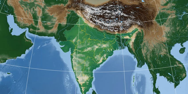
Question: Identify the following with the help of map reading.
(i) The island groups of India lying in the Arabian Sea and the Bay of Bengal.
Answer: Lakshadweep Islands and Andaman and Nicobar Islands
(ii) The countries constituting the Indian Sub-continent.
Answer: Pakistan, Afghanistan, Nepal, Bhutan, Myanmar and Bangladesh.
(iii) The states through which the Tropic of Cancer passes.
Answer: Gujarat, Rajasthan, Madhya Pradesh, Chhattisgarh, Jharkhand, Paschim Banga, Tripura and Mizoram.
(iv) The northernmost latitude in degrees.
Answer: 37° 6’N
(v) The southernmost latitude of the Indian mainland in degrees.
Answer: 8° 4’N
(vi) The eastern and the Westernmost longitude in degrees.
Answer: 68° 7’E and 97° 25′ E
(vii) The place situated on the three seas.
Answer: Kanyakumari
(viii)The straight separating Sri Lanka from India.
Answer: Palk Strait
(ix) The Union Territories of India.
Answer: Andaman and Nicobar Islands, Chandigarh, Dadra and Nagar Haveli, Daman and Diu, Lakshadweep, Puducherry and Delhi.