Our Country: India – 6th Class NCERT CBSE Social Science (Geography) Chapter 07
Question: Answer the following questions briefly.
- Name the major physical divisions of India.
- India shares its land boundaries with seven countries. Name them.
- Which two major rivers fall into the Arabian Sea?
- Name the delta formed by the Ganga and the Brahmaputra.
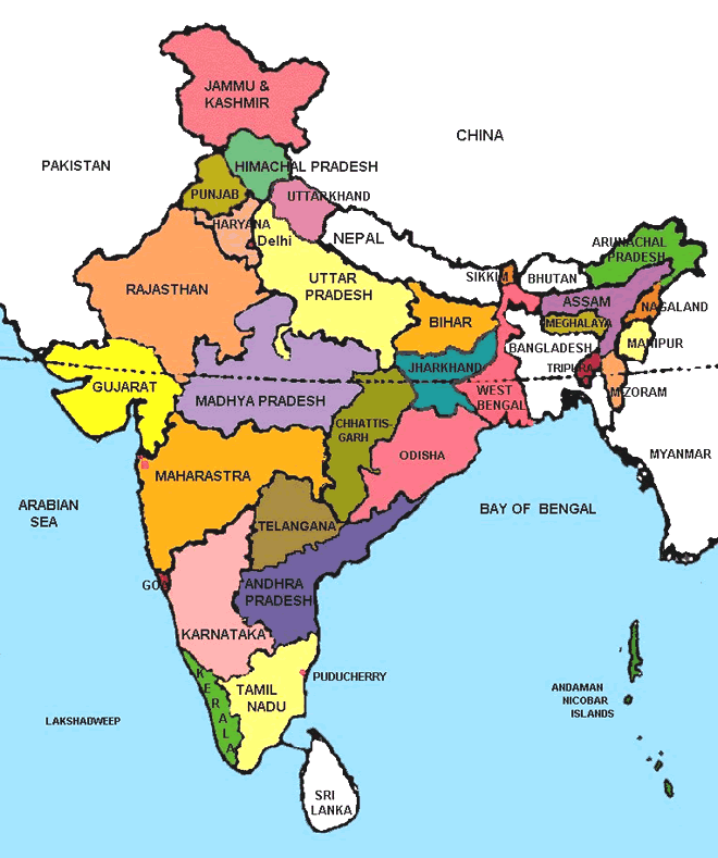
- How many States and Union Territories are there in India? Which States have a common Capital?
- Why do a large number of people live in the Northern plains?
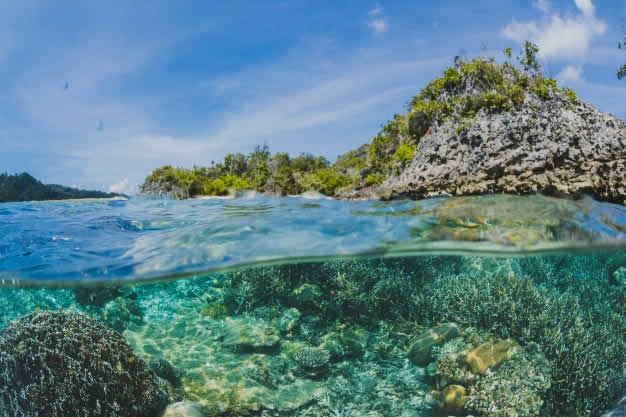
- Why is Lakshadweep known as a coral island?
Answer:
- The major physical divisions of India are: mountains, plateaus, plains, coasts and islands.
- The countries with which India shares its land boundaries are: Pakistan, Afghanistan, China, Nepal, Bhutan, Bangladesh and Myanmar.
- The two major rivers that fall into the Arabian Sea are: Narmada and Tapi.
- The Sunderban delta is formed by the Ganga and the Brahmaputra.
- There are 29 States and 7 Union Territories in India. Punjab and Haryana are the States that have a common Capital (Chandigarh). Also Telangana and Andhra Pradesh share common capital- Hyderabad- for a period of 10 years.
- The Northern Indian plains have been formed by the alluvial deposits laid down by rivers. These river plains provide fertile land for cultivation. This is why a large number of people live in the Northern plains.
- Lakshadweep Islands have been formed from corals, that is, the skeletons of tiny marine animals called Polyps. Hence, Lakshadweep Islands are known as coral islands.
Our Country: India – Question: Tick the correct answers.
- The southernmost Himalayas are known as
(i) Shiwaliks (ii) Himadri (iii) Himachal - Sahyadris is also known as
(i) Aravalli (ii) Western Ghats (iii) Himadri - The Palk Strait lies between the countries
(i) Sri Lanka and Maldives
(ii) India and Sri Lanka
(iii) India and Maldives - The Indian islands in the Arabian Sea are known as
(i) Andaman and Nicobar Islands
(ii) Lakshadweep Islands
(iii) Maldives - The oldest mountain range in India is the
(i) Aravalli Hills (ii) Western Ghats (iii) Himalayas
Answer:
- The southernmost Himalayas are known as
(i) Shiwaliks √ (ii) Himadri (iii) Himachal - Sahyadris is also known as
(i) Aravali (ii) Western Ghats √ (iii) Himadri - The Palk Strait lies between the countries
(i) Sri Lanka and Maldives
(ii) India and Sri Lanka √
(iii) India and Maldives - The Indian islands in the Arabian Sea are known as
(i) Andaman and Nicobar Islands
(ii) Lakshadweep Islands √
(iii) Maldives - The oldest mountain range in India is the
(i) Aravalli Hills √ (ii) Western Ghats (iii) Himalayas
Question: Fill in the blanks.
- India has an area of about __________.
- The Greater Himalayas are also known as ___________.
- The largest state in India in terms of area is ___________.
- The river Narmada falls into the ____________ Sea.
- The latitude that runs almost halfway through India is ___________.
Answer:
- India has an area of about 3.28 million square kilometres.
- The Greater Himalayas are also known as Himadri.
- The largest state in India in terms of area is Rajasthan.
- The river Narmada falls into the Arabian Sea.
- The latitude that runs almost halfway through India is the Tropic of Cancer.
Our Country: India – Question: Fill in the blanks.
- India has an area of about…………..
- The Greater Himalayas are also known as……………
- The largest state in India in terms of area is……………..
- The river Narmada falls into the……………
- The latitude that runs almost halfway through India is ……………….
Answer:
- 3.28 million sq. km
- Himadri
- Rajasthan
- Arabian
- The Tropic of Cancer
Fill in the Blanks
Question: Fill in the blanks with appropriate words to complete each sentence:
- India is the second most populous country of the world after ……………
- The Himalayan mountains are divided into …………… main parallel ranges.
- The Great Indian desert lies to the ……………. part of India.
- ……….. and ……….. are west-flowing rivers that fall into the Arabian Sea.
- Lakshadweep islands are located in the ……………….
- The western coastal plains are very ………………
Answer:
- China
- three
- Western
- Narmada, Tapi
- Arabian Sea
- narrow
True / False
Question: State whether these sentences are true (T) or false (F).
- Lakshadweep islands are coral islands.
- The eastern coastal plains are much broader.
- The Northern Indian plains lie to the south of the Himalayas.
- The Bay of Bengal lies east to India.
- Canada has five time zones.
- High concentration of population is found in plateaus.
Answer:
- True
- False
- True
- True
- False
- False
Matching Skill
Question: Match the items in column A correctly with those given in column B.
(ii) The Bay of Bengal
(iii) The Arabian Sea
(iv) The Indian Ocean
(v) The Peninsular Plateau
(vi) The Eastern Ghats
(vii) The Western Ghats
(b) West
(c) Broken and uneven
(d) Triangular in shape
(e) North
(f) Continuous
(g) East
Answer:
- (e)
- (g)
- (b)
- (a)
- (d)
- (c)
- (f)
Our Country: India – Question: What is the north-south extent of India?
Answer: The north-south extent from Kashmir to Kanyakumari is about 3,200 km.
Question: What is the east-west extent of India?
Answer: The east-west extent from Arunachal Pradesh to Kuchchh is about 2,900 km.
Question: How does the local time change?
Answer: The local time changes by four minutes for every one degree of longitude,
Question: What is the difference between the time of sunrise in Arunachal Pradesh and Gujarat?
Answer: The difference between the time of sunrise in Arunachal Pradesh and Gujarat is two hours.
Question: On what basis have the states been formed?
Answer: The states have been formed on the basis of languages,
Question: What does Himalayas mean?
Answer: Himalaya means the abode of snow (Him + alaya).
Question: Where are the world’s highest peaks located?
Answer: The world’s highest peaks are located in the Great Himalayas or Himadri.
Question: What is a peninsula?
Answer: A peninsula is a piece of land surrounded by water on all the three sides
Question: Define the term desert.
Answer: A desert is a dry, hot and sandy stretch of land with very little vegetation
Question: Name the two important hill ranges that lie in the peninsula plateau
Answer: The Vindhyas and the Satpuras.
Question: What is called the mouth of the river?
Answer: The point where rivers enter the sea is called the mouth of the river
Question: What are called polyps?
Answer: Polyps are very small marine animals.
Question: What is the difference between the western coastal plains and the eastern coastal plains?
Answer: The Western coastal plains are very narrow while the eastern coastal plains are much broader.
Question: Name the rivers which fall into the Bay of Bengal?
Answer: Mahanadi, Godavari, Krishna and Kaveri.
Our Country: India – Short Answer Type Questions
Question: Mention the political and administrative divisions of India.
Answer: India is a vast country. Hence, for administrative purposes, it is divided into 28 states and 7 Union Territories. New Delhi is the capital of India. The formation of states has been made on the basis languages. Rajasthan is the largest state while Goa is the smallest state in terms of area. These states have been further divided into districts.
Question: Write a short note on the coastal plains of India.
Answer: The coastal plains lie to the West of the Western Ghats and the East of the Eastern Ghats. The Western coastal plains are narrow while the eastern coastal plains are much broader. There are several east-flowing rivers such as Mahanadi, Godavari, Krishna and Kaveri. These rivers have formed fertile deltas at their mouth.
Question: Write a short note on the two groups of islands of India.
Answer: The two groups of islands are – Lakshadweep islands and Andaman and Nicobar islands. Lakshadweep islands are located in the Arabian Sea. These are coral islands located off the coast of Kerala. The Andaman and Nicobar islands are located in the Bay of Bengal.
Question: How are coral islands formed?
Answer: Corals are skeletons of very small marine animals called polyps. When the living polyps die, their skeletons are left. Other polyps grow on top of the hard skeleton which grows higher and higher, thus forming the coral islands.
Question: What do you know about the boundaries of India? Explain in brief.
Answer: Our country has a vast geographical expanse. In the north, it is bound by the lofty Himalayas. In the west, lies the Arabian Sea, in the east it is bound by the Bay of Bengal and in the south lies the Indian’ Ocean.
Question: Describe the geographical extent of India.
Answer: India has an area of about 3.28 million sq. Km. The north-south extent from Kashmir to Kanyakumari is about 3,200 km. And the east-west extent from Arunachal Pradesh to Kuchchh is about 2,900 km. The lofty mountains, the Great Indian Desert, the Northern Plains, the uneven plateau surface and the coasts and islands present a diversity of landforms.
Our Country: India – Question: Describe the locational extent of India.
Answer: India is located in the northern hemisphere. The Tropic of Cancer (23° 30′ N) passes almost halfway through the country. From south to north, mainland of India extends between 8° 4′ N and 37° 6′ N latitudes. From west to east, India extends between 68° 7′ E and 97° 25′ E longitudes. If we divide the world into eastern and western hemisphere, India will belong to eastern hemisphere.
Question: Describe the effect of east-west extent of India on time.
Answer: The west to eats extent leads to difference in local time from meridian to meridian. The local time changes by four minutes for every one degree of longitude. The sun rises two hours earlier in the east, Le. Arunachal Pradesh than in the west, ie. (Gujarat). The local time of longitude of 82° 30′ E has been taken as the Indian Standard Time. This longitude is also known as the Standard Meridian of India. Its time is taken as the standard throughout the country.
Question: Describe the major physical division of India.
Answer: India has a diverse physical feature, such as mountains, plateaus, plains, coasts and islands.
- The Himalayas: The Himalayas stand sentinels in the north. The Himalayas mountains are divided into three main parallel ranges. The northernmost is the Great Himalaya or Himadri. The world’s highest peaks are located in this range. Middle Himalayas or Himachal lies to the south of Himadri. The Shiwalik is the southernmost range.
- The Northern Indian Plains: They lie to the south of the Himalayas. They are usually level and flat. These are fertile regions and are suitable for cultivation. Thick population is found here.
- The Great Indian Desert: It lies to the western part of the country. It is a sandy stretch of land. Rainfall is very poor hence very little vegetation is found here.
- The Peninsular Plateau: It is triangular in shape. It lies to the south of northern plains. Its relief is highly uneven. Numerous hill ranges and valleys are found here. Aravalli hills lie to the north-west side. The Vindhyas and the Satpuras are other important ranges. The Narmada and Tapi flow through these ranges. These west-flowing rivers fall into the Arabian Sea. On the west of the plateau lie the Western Ghats also known as Sahyadris. On the east lie the Eastern Ghats. This plateau is rich in minerals like coal and iron ore.
- Coastal Plains: They lie to the West of the Western Ghats and East of the Eastern Ghats. The rivers Mahanadi, Godavari, Krishna and Kaveri (all east flowing rivers) fall into the Bay of Bengal. They have formed fertile deltas at their mouth.
- Islands: Two groups of islands are integral part of the country. Lakshadweep islands are located in the Arabian Sea while Andaman and Nicobar islands lie to the South-east of the Indian mainland in the Bay of Bengal.
Map Skills
Question: On an outline map of India, show its neighboring countries.
Answer:

Question: On an outline political map of India, show all the states and union territories.
Answer: