Globe: Latitudes and Longitudes – 6th Class NCERT CBSE Social Science (Geography) Chapter 02
Question: Answer the following questions briefly.
- What is the true shape of the Earth?
- What is a globe?
- What is the latitudinal value of the Tropic of Cancer?
- What are the three heat zones of the Earth?
- What are the parallels of latitude and meridians of longitudes?
- Why does the Torrid Zone receive maximum amount of heat?
- Why is it 5.30 P.M. in India and 12.00 noon in London?
Answer:
- Earth is slightly flattened at the North and South Poles, and bulges in the middle. The shape of the Earth is described as a ‘geoid’, that is, ‘an Earth-like shape’.
- Globe is a true model (miniature form) of the Earth.
- The Tropic of Cancer lies 23½ ° north of the Equator.
- The three heat zones of the Earth are: the Torrid Zone, the Temperate Zone and the Frigid Zone.
- All parallel circles from the Equator up to the Poles are called parallels of latitudes.
The lines of references running from the North Pole to the South Pole are called meridians of longitudes. - The area between the Tropic of Cancer and the Tropic of Capricorn is known as the Torrid Zone. The mid-day Sun is exactly overhead at least once a year on all the latitudes in this area; hence, this area receives maximum amount of heat.
- In London, the Greenwich Mean Time (GMT) is followed. The Indian Standard Meridian is located 82½° east of the Prime Meridian. Thus the Indian Standard Time (IST) is 5 hours and 30 minutes ahead of GMT. So, when it is 12 noon in London, it is 5.30 P.M. in India.
Question: Tick the correct answers.
- The value of the Prime Meridian is
(i) 90° (ii) 0° (iii) 60° - The Frigid Zone lies near
(i) the Poles (ii) the Equator (iii) the Tropic of Cancer - The total number of longitudes are
(i) 360 (ii) 180 (iii) 90 - The Antarctic Circle is located in
(i) the Northern Hemisphere
(ii) the Southern Hemisphere
(iii) the Eastern Hemisphere - Grid is a network of
(i) parallels of latitudes and meridians of longitudes
(ii) the Tropic of Cancer and the Tropic of Capricorn
(iii) the North Pole and the South Pole
Answer:
- The value of the Prime Meridian is
(ii) 0° - The Frigid Zone lies near
(i) the Poles - The total number of longitudes are
(i) 360 - The Antarctic Circle is located in
(ii) the Southern Hemisphere - Grid is a network of
(i) parallels of latitudes and meridians of longitudes
Question: Fill in the blanks.
- The Tropic of Capricorn is located at __________.
- The Standard Meridian of India is _________.
- The 0° Meridian is also known as __________.
- The distance between the longitudes decreases towards _________.
- The Arctic Circle is located in the _________ Hemisphere.
Answer:
- The Tropic of Capricorn is located at 23½° south of the Equator.
- The Standard Meridian of India is 82½° E.
- The 0° Meridian is also known as the Prime Meridian.
- The distance between the longitudes decreases towards the Poles.
- The Arctic Circle is located in the Northern Hemisphere.
Fill in the Blanks:
Fill in the blanks with appropriate words given to complete each sentence:
- Russia extends over………………… time zones.
- As we move away from the equator, the size of the latitudes ……………………………
- The poles fall in the……………..
- To locate a point, we need to know its latitude, as well as……………………………
- The British Royal Observatory is located in ……………………….. UK.
- A hemisphere is one …………….. of a sphere.
- Latitudes and longitudes form a………………………
- All places lying on the same ………………… have the same time.
- When it is 7.30 pm on August 16 in Greenwich, it is………………………….. (time) on ……………(date) in Chennai.
Answers:
- 11
- decreases
- Frigid
- longitude
- Greenwich
- half
- grid
- longitude
- 1 am on August 17
True / False:
State whether these sentences are true (T) or false (F).
- The axis of the earth is not actually tilted as depicted in a globe.
- The equator is the 0-degree latitude.
- The Prime Meridian is the 180-degree longitude.
- More than half of India lies in the Frigid Zone.
- The Tropic of Capricorn does not pass through India.
- The two Temperate Zones maintain a moderate climate.
- The time at a place in the east of Greenwich is ahead of that in Greenwich,
- The earth rotates from west to east.
- The standard longitude for Indian time is the 64° longitude.
Answers:
- False
- True
- False
- False
- True
- True
- True
- True
- False
Matching Skill:
Match the items in column A correctly with those given in column B.
- The number of time zones in the whole world
- The number of time zones in India
- The number of time zones in Russia
- Difference between the local times of Greenwich and a place at 180°longitude (in hours)
- Number of minutes by which local times at longitudes at one degree difference, differ
- Number of points having the same aet of latitude and longitude
- 12
- 1
- 5
- 4
- 11
- 24
Answer:
- (f)
- (b)
- (e)
- (a)
- (d)
- (b)
Very Short Answer Type Questions
Question: What is the globe?
Answer: Globe is a true model of the earth. It shows the earth in a small form.
Question: What are the advantages of the globe?
Answer: The globe is small in shape, is convenient to carry and use, and depicts all features of the earth.
Question: What are the two types of lines needed to locate any point on the earth’s surface?
Answer: Latitudes and longitudes are required to locate any point on the earth’s surface.
Question: Define latitude.
Answer: One of the imaginary circles parallel to the Equator is called latitude.
Question: Define longitude.
Answer: One of the imaginary circles parallel to the Prime Meridian is called longitude.
Question: Which place is used as a standard for time all over the world?
Answer: Greenwich in Britain is used as a standard for time all over the world.
Question: Geographically, what is the time difference between Dwarka in Gujarat and Dibrugarh in Assam?
Answer: The time difference between Dwarka and Dibrugarh is of 1 hour 45 minutes.
Question: A particular city lies in the time zone-2. What does this mean?
Answer: This means that the city’s local time is 2 hours behind Greenwich.
Question: What does the time ’12 noon’ signify at any place?
Answer: ’12 noon’ refers to the time when the sun is at the highest point in the sky.
Question: Which heat zone does the equator lie in?
Answer: The equator lies in the Torrid Zone.
Short Answer Type Questions
Question: A cricket match begins at 10.30 am on January 10 in New Zealand (time zone of +12). TeU. the time in Greenwich when it is shown live on TV there.
Answer: New Zealand lies in time zone +12, Le. it is 12 hours ahead of Greenwich, or Greenwich is 12 hours behind New Zealand. So when it is 10.30 am on January 10 in New Zealand, it is 10.30 pm on January 9. So the cricket match will be telecast from 10.30 pm on Jan 9 in Greenwich.
Question: Why do we have the concept of time zone?
Answer: The sun does not shine with the same intensity over all parts of the world at a particular time. If it is overhead at one place (midday), then it does not shine at all (midnight) at the place directly opposite to that place on the earth. So if we have the same time, then 12 noon will mean midday at one place, and midnight at another. To avoid such an awkward system, we have the system of time zones, so that everywhere a particular time means the same stage of the day.
Question: Write a short note on Heat Zones.
Answer: Heat zones are the different zones of the earth, where the sun’s rays fall differently, thus causing different climate patterns. These zones are called the Torrid Zone, the two Temperate Zones, and the two Frigid Zones. The Torrid Zone is very hot since the sun shines overhead here. The Temperate Zones maintain a moderate climate, and the Frigid Zones are extremely cold.
Question: Which heat zone do these places lie in?
- 20° N
- 36 ½° S
- 45° N
- 88° S
- 12° S
Answer:
- Torrid
- Temperate
- Temperate
- Frigid
- Torrid
Question: How do latitudes and longitudes help in locating a point? Why is only one of them insufficient in doing this?
Answer: Latitudes and longitudes form agrid. Two different points may lie on the same latitude, or the same longitude. But there exists only one point where a latitude and longitude intersect. So a point can be identified with the help of the latitude and longitude on which it lies.
Long Answer Type Questions
Question: In the grid shown below, ten points are marked (a to j). Using the figures marked with the grid, identify the latitudes and longitudes of these points.
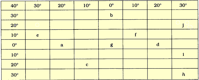
Answer:
b
c
d
e
f
g
h
i
j
30° N
20° S
0°
10° N
10° N
0°
40° S
10° S
20° N
0°
10° W
20° E
30° W
10° E
0°
40° W
20° E
30° E